Vegetos

(An International Journal of Plant Research & Biotechnology)
(eISSN: 2229-4473)
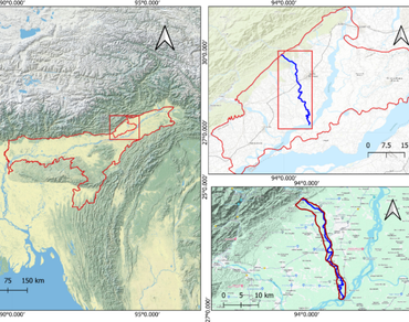
Assessment of land use and land cover (LULC) and land surface temperature (LST) dynamics with normalized difference vegetation index (NDVI) detection in the Ranganadi River Basin, Assam, Northeast India
*Article not assigned to an issue yet
Borah Homen, Dutta Ranjit, Das Udipta, Patnaik Santanu Kumar
Research Articles | Published: 04 December, 2025
First Page: 0
Last Page: 0
Views: 397
Keywords: GIS, Remote sensing, Land use land cover, LST, NDVI
Abstract
This study explores land use and land cover (LULC) changes and observes the relationship between land surface temperature (LST) and the normalized difference vegetation index (NDVI) in the Ranganadi River Basin, Assam, Northeast India, over the period from 1989 to 2023. The basin is highly vulnerable to environmental degradation, however previous research on the area has failed to simultaneously analyze LULC, LST, and NDVI trends. GIS and remote sensing techniques were used to identify six LULC categories from Landsat-5 and Landsat-8 imagery: dense vegetation, sparse vegetation, agricultural land, water bodies, sand bars, and settlements. Between 1989 and 2023, the basin underwent significant land cover transformations. Water bodies declined from 12.36 to 7.71%, while agricultural land expanded from 18.94 to 24.45%. Sand bar areas increased in 2001 but subsequently reverted to their 1989 extent. Settlement areas rose from 30.71 to 32.03%, sparse vegetation decreased slightly, and dense vegetation declined markedly from 28.64 to 21.62%. NDVI values ranged from − 0.058 to 0.686, reflecting variations in vegetation cover. LST analysis revealed a pronounced warming trend, with values increasing from 3.93 to 27.18 °C and peaking between 18.4 and 27.18 °C in 2023. Between 2001 and 2023, the sharpest rise occurred largely motivated by urbanization, population growth, and climate change. The 2023 analysis shows a contrary LST–NDVI relationship, with cooler surfaces in areas of higher vegetation cover. This study provides valuable insights for environmentalists and land-use planners in promoting sustainable management of the Ranganadi River Basin.
References
Abdo HG, Almohamad H, Al Dughairi AA, Al-Mutiry M (2022) GIS-based frequency ratio and analytic hierarchy process for forest fire susceptibility mapping in the western region of Syria. Sustain 14(8):4668
Aneseyee AB, Elias E, Soromessa T, Feyisa GL (2020) Land use/land cover change effect on soil erosion and sediment delivery in the Winike watershed, Omo Gibe Basin, Ethiopia. Sci Total Environ 728:138776
Avdan U, Jovanovska G (2016) Algorithm for automated mapping of land surface temperature using LANDSAT 8 satellite data. J Sens 2016(1):1480307
Borgohain PL (2019) Downstream impacts of the Ranganadi hydel project in Brahmaputra Basin, India: implications for design of future projects. Environ Dev 30:114–128
Cao JS, Deng ZY, Li W, Hu YD (2020) Remote sensing inversion and spatial variation of land surface temperature over mining areas of Jixi, Heilongjiang, China. PeerJ 8:e10257
Chetia A, Das DN (2021) Enumeration of fresh water crab and aquatic fauna in Ranganadi River Basin, Assam. In: Research trends on fish and fisheries in mountain waters of eastern Himalayan region
Choudhury U, Singh SK, Kumar A, Meraj G, Kumar P, Kanga S (2023) Assessing land use/land cover changes and urban heat island intensification: a case study of Kamrup Metropolitan District, Northeast India (2000–2032). Earth 4(3):503–521
Das AK, Sah RK, Hazarika N (2012) Bankline change and the facets of riverine hazards in the floodplain of Subansiri-Ranganadi Doab, Brahmaputra Valley, India. Nat Hazards 64:1015–1028
Eb I, Lawal O, Tn D (2024) Temporal trends in vegetation health across ecological zones of South-South region of Nigeria (2000–2020). J Adv Multidiscip Res Stud 4(6):453–468
Ghobadi Y, Pradhan B, Shafri HZM, Kabiri K (2013) Assessment of spatial relationship between land surface temperature and landuse/cover retrieval from multi-temporal remote sensing data in South Karkheh Sub-basin, Iran. Arab J Geosci 8:525–537
Huo J, Peng C (2023) Depletion of natural resources and environmental quality: prospects of energy use, energy imports, and economic growth hindrances. Resour Policy 86:104049
Ingrao C, Strippoli R, Lagioia G, Huisingh D (2023) Water scarcity in agriculture: an overview of causes, impacts and approaches for reducing the risks. Heliyon. https://doi.org/10.1016/j.heliyon.2023.e18507
Kalita A, Bormudoi A, Saikia AP (2024) A study on climate-driven vulnerabilities in the Ranganadi River basin: sand-casting impacts on rural households. Environ Qual Manag 34(1):22247
Khan R, Li H, Basir M, Chen YL, Sajjad MM, Haq IU, Ullah B, Arif M, Hassan W (2022) Monitoring land use land cover changes and its impacts on land surface temperature over Mardan and Charsadda Districts, Khyber Pakhtunkhwa (KP), Pakistan. Environ Monit Assess 194(6):409
Lemenkova P (2021) ISO cluster classifier by ArcGIS for unsupervised classification of the Landsat TM image of Reykjavík. Bull Nat Sci Res 11(1):29–37
Liang BP, Li Y, Chen KZ (2012) A research on land features and correlation between NDVI and land surface temperature in Guilin City. Remote Sens Technol Appl 27(3):429–435
Maurya S, Gupta M, Chitra R (2018) Anti-erosion and river training works along the banks of Ranganadi River, Assam. Int J Eng Appl Sci Technol 2:3
Pandey A, Mondal A, Guha S, Upadhyay PK, Singh D (2022) Land use status and its impact on land surface temperature in Imphal city, India. Geol Ecol Landsc 8(3):261–275
Pandey A, Mondal A, Guha S, Upadhyay PK, Singh D (2023) A long-term analysis of the dependency of land surface temperature on land surface indexes. Pap Appl Geogr 9(3):279–294
Pandey A, Mondal A, Guha S, Upadhyay PK, Rashmi N, Kundu S (2024) Comparing the seasonal relationship of land surface temperature with vegetation indices and other land surface indices. Geol Ecol Landsc. https://doi.org/10.1080/24749508.2024.2392391
Popović P, Devauchelle O, Abramian A, Lajeunesse E (2021) Sediment load determines the shape of rivers. Proc Natl Acad Sci USA. https://doi.org/10.1073/pnas.2111215118
Prakasam C, Sarkar P (2024) Spatio-temporal change detection of channel migration using geo-spatial techniques: a study on Ranganadi River basin of Lakhimpur District, Assam. J Harbin Eng Univ 45(6):356–372
Richardson AD, Jenkins JP, Braswell BH, Hollinger DY, Ollinger SV, Smith M (2007) Use of digital webcam images to track spring green-up in a deciduous broadleaf forest. Oecologia 152(2):323–334
Said M, Hyandye C, Komakech HC, Mjemah IC, Munishi LK (2021) Predicting land use/cover changes and its association to agricultural production on the slopes of Mount Kilimanjaro, Tanzania. Ann GIS 27(2):189–209
Tilman D, Balzer C, Hill J, Befort BL (2011) Global food demand and the sustainable intensification of agriculture. Proc Natl Acad Sci 108(50):20260–20264
Ullah W, Ahmad K, Ullah S, Tahir AA, Javed MF, Nazir A, Abbasi AM, Aziz M, Mohamed A (2023) Analysis of the relationship among land surface temperature (LST), land use land cover (LULC), and normalized difference vegetation index (NDVI) with topographic elements in the lower Himalayan region. Heliyon. https://doi.org/10.1016/j.heliyon.2023.e13322
Van Leeuwen B, Tobak Z, Kovács F (2020) Machine learning techniques for land use/land cover classification of medium resolution optical satellite imagery focusing on temporary inundated areas. J Environ Geogr 13:43–52
Viana CM, Freire D, Abrantes P, Rocha J, Pereira P (2021) Agricultural land systems importance for supporting food security and sustainable development goals: a systematic review. Sci Total Environ 806:150718
Winkler K, Fuchs R, Rounsevell M, Herol M (2021) Global land use changes are four times greater than previously estimated. Nat Commun 12(1):2501
Wu Y, Knudby A, Pahlevan N, Lapen D, Zeng C (2024) Sensor-generic adjacency-effect correction for remote sensing of coastal and inland waters. Remote Sens Environ 315:114433
Xie F, Fan H (2021) Deriving drought indices from MODIS vegetation indices (NDVI/EVI) and land surface temperature (LST): is data reconstruction necessary? Int J Appl Earth Obs Geoinf 101:102352
Author Information
Department of Botany, Madhabdev University, Lakhimpur, India